Burdick Family Land Records, Wexford County, Michigan Liber 4 Page 491

This entry is part 3 of 99 in the series Deeds in the Family

I am posting information gleaned from land records in the areas where our family’s ancestors resided. You can read more about this project in the overview. You may also check my deed record listing, which I will update with each post.

I have elected to post all the deeds related to George W. Burdick and his family first.

Date: 28 Dec 1876
Liber: 4
Page: 491
Location: Wexford Co. MI
Grantor: Warren Seaman & Mary Seaman his wife of Cedar Creek, Wexford, MI
Grantee: George W. Burdick of the same place
Witnesses: Ezra Harper, Meda or Neda Moffit
Type of deed: Warranty
Rec’d and recording: 29 Dec 1876, 9 a.m.
Clerk/registrar: Sturtevant
Location of land: Wexford Co. MI
Consideration: $200
Notes:
Description: Lots 8,9,& 10 of block B and an undivided 1/2 interest in lots 3 & 4 block B in Seaman & Maqueston village plot in the NW 1/4 of Section 10 T23N, R9W according to survey on file.

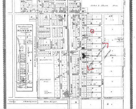
I have used a map from the 1889 Wexford County Atlas1 posted on the Michigan County Histories and Atlases site to illustrate the location of block B in Seaman and Maqueston’s village plot. This is a thumbnail, you may see a larger view by clicking it.

block B

A closer look at block B reveals that lots 8-10 are conveniently located on “Seaman St.”, which is now known as Michigan Avenue. Michigan Avenue is also old US 131; the new expressway named US 131 bypassed Manton. The lots for which Burdick received 1/2 interest are located on First Street. One block north of First Street is the section line, running along the section line is  “Main Street”,  also known as 16 mile road. Until recently this road was known as M-42; but the state of Michigan has turned control back to Wexford County. The corner of Michigan and Main is the “main” downtown corner in Manton.

block b 8-9-10 3-4

  1. E.L. Hayes & Co., Atlas of Wexford County, Michigan / compiled by Eli L. Hayes from government surveys, county and township records, and personal investigations and observations (Chicago, Ill.: E.L. Hayes & Co., 1889), 21; digital images, The University of Michigan. Michigan County Histories and Atlases. http://name.umdl.umich.edu/3928170.0001.001 : accessed 2 November 2009.

Save a PDF Using Print

This article describes how to save a PDF file created from a view of the Michigan Subdivision Maps site. I was able to save a copy by printing it to PDF. If you have a PDF writer of any kind installed on your computer you can do this with any printable display. These instructions are for a PC, and are specific to the subdivision plat maps, the procedure may differ on other sites, but I have successfully saved deeds, death certificates, obituaries and other images using this method. I have no information on how to use an Apple computer.

  1. Check your printers folder to be sure you have a PDF printer.

    print folder

  2. You can see that I have a several. If you see a PDF printer, you can proceed.
  3. Under view, select “fit window” .
    fit window

  4. The subdivision maps have their own printer icon. Other documents may be saved by using your browser’s default print icon, of by selection “File, Print” from the menus.
    print icon

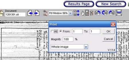
  5. When the box comes up. Select “whole image”, not current view.

    site print box

  6. Click OK, and your print dialog box is displayed.

    comp print box

  7. Select your PDF print driver from the available printers, click OK. A “save” dialog box is displayed. Give your map a name and select a location, click OK.

    name print

  8. You can then open the PDF in any PDF viewer on your computer.

You can view a sample of the plat of Manton, Michigan which I saved using this procedure. You will need Adobe Acrobat® to view the plat.

Burdick Family Land Records -Liber 3 Page 603 – George Burdick

This entry is part 2 of 99 in the series Deeds in the Family

I am posting information gleaned from land records in the areas where our family’s ancestors resided. You can read more about this project in the overview. You may also check my deed record listing, which I will update with each post.

The names of members of George W. Burdick’s family appear quite often in the Wexford County, Michigan deeds. The next listing for George is recorded in Liber 3 on page 326.

Date: 26 May 1876
Liber: 3
Page: 603
Location: Wexford County, MI
Grantor: George Burdick & wife
Grantee: George W. Burdick
Witnesses: Ezra Harper Justice of the Peace, Mrs. J.P. Fenton
Type of deed: Quit Claim Deed
Rec’d and recording: 16 May 1877 7 p.m.
Clerk/registrar: C.E. Manktelow, Clerk
Location of land: Wexford County, MI
Consideration: $26.54
Notes:
Description: Commencing at the northwest corner of Sec 10 T23N R9W and running east 185 ft., then south 85 ft., then west 185 ft. then north 85 ft to the start.

What is going on here? This deed is for the same property as the deed recorded in liber 3, page 326. George Burdick received by quit claim deed, on 26 May 1876, some rights to the property, and is apparently selling those rights to Jacob Sturr.

Instead of rechecking the old county history again, this time I used the subdivision maps. Using the advances search, I searched for T23N R9W. Seaman & Maqueston’s addition was one of 17 results. I was able to save a copy by printing it to PDF, I will show how to do that in a future post. However, even with out saving a copy, it was easy to read the information on the plat document:

The plat was recorded in the Wexford County office on 18 October, 1874. The plat of Seamons & Mcqueston’s addition to the city of Manton was, “Received & Filed in the Auditor General’s office August 11, 1875.” Now, what am I learning by this exercise? George Burdick never lived on this land, he obtained some rights to it, and signed them on to someone else. How does that fit into my puzzle?

My George Burdick timeline:

27 April 1827 Birth: Berlin, Rensselaer Co., NY
1850 Census: Andover, Allegany Co., NY
1855 Marriage: Mary Jane Abbott
1850 Census: Andover, Allegany Co., NY
29 March 1856 Daughter: Susie Melissa born, Andover, Allegany Co., NY
1860 Census: Andover Allegany County, New York
24 Oct 1860 Son: Fink Clement born Andover, Allegany Co., NY
24 Oct 1860 – 23 Jn 1868 Migration: New York to Pennsylvania
23 June 1868 Daughter: Mable Genevieve born, Eleven Mile, Potter Co., PA
23 June -May 1870 Migration: Pennsylvania to Michigan
27 Aug 1870 Census: Colfax, Wexford County, Michigan
11 Jan 1871 Daughter: Gertie W. born Colfax, Wexford Co., MI
12 Mar 1874 News item: The Grand Traverse Herald; Boardman, Grand Traverse County, Michigan Listed as arrivals at the Boardman River House for the week ending March 9th: (lengthy list) Geo. W Burdick, Manton.
20 May 1874 Purchased Interest: E 1/2 of the NE 1/4 Sec. 4 T23N R10W Wexford Co., MI
26 May 1876 Sold Interest: E 1/2 of the NE 1 /4 Sec. 4 T23N R10W Wexford Co., MI
1880 Census: Colfax Township, Wexford County, Michigan
8 Jan 1885 News item: the Grand Traverse Herald “Geo. W. Burdick will log quite extensively in Colfax this winter.”
1910 Census: Colfax Township, Wexford County, Michigan
24 Oct 1914 Death: Irons, Lake County, Michigan
26 Oct 1914 Burial: Colfax Township, Wexford County, Michigan

George, like many of the pioneers, is listed as a farmer on the census. However, the main business in Wexford County, Michigan during the time these deeds were recorded was logging. Farming was done in the good weather, and loggers worked in the woods during the winter. The land had to be cleared before anything could be build. Judge William Peterson, in his excellent history of Cadillac, Wexford County, said:

Travel away from the road was laborious and, at places, impossible. The height and density of the forest blocked out the sunlight so as to create a perpetual twilight,……..brush and trees were so thick that it was impossible to see more than eight or ten feet…..1

Although this quote describes the general conditions near Sherman, Wexford County’s first settlement, in 1854, it gives a pretty good idea what things may have been like in a newly settled area, even years later.

Wexford County was divided into four townships in 1870, and Colfax was comprised of 18 surveyed townships of 6 square miles each: Townships 21, 22 and 23 north of ranges 5,6,7,8,9 and 10 west. The entire 1870 census of Colfax Township, Wexford County, which included the current city of Manton and this “addition” lists 172 people, not families, but individuals.

There was no transportation to take crops to centers of population to sell them, these pioneers were not “farming” for a living, just enough to have food to eat. George Burdick was probably buying rights to timber, logging the land over, and selling the rights after he had removed what he wanted. He had probably cleared enough land on his homestead to grow food to eat, and was therefore listed as a farmer, was was most of the population.

1. Peterson, The Honorable William R., The View From Courthouse Hill: Privately printed: 1972, p 9.

Back Up!

If you pursue genealogy professionally, or as a hobby, the odds are you collect a lot of information in electronic format. The items I have range in size and importance, but they include e-mail (with family information) from near and far, scanned information, photographs from the past and present, digital copies from far and wide, and several Rootsmagic databases. I have copies of minutes and financial reports for my genealogical society. I have personal e-mail, letters and messages from cousins near and far. Can I backup in time and retrieve all that information? Of course not.

How much time, energy and money have you spent accumulating family history and other data on your computer? Do you have a large music collection? Your checking, savings and investment accounts? The photos of your children and grandchildren? Information on your family history which you have collected over 20 or 30 years? Copies of old family photos your cousin sent you? The list goes on and on. Can you backup and recreate it? The answer is undoubtedly no.

My best guess is that if electronic information is gone, most of it is gone forever. Many people think of a hard drive failure, and that is one aspect of data loss. But consider this, I recently received an e-mail from a lady who experienced a fire at her home. Her notebooks of genealogical data were heavily damaged, in addition recovering the data from her computer’s hard drive was in doubt. The communication, from someone who had invested years of her life in exploring, collecting and cataloging her family history was heartbreaking. She could not backup and retrieve her data.

As each year passes, personal genealogical collections increase, and electronic files become a larger portion of what genealogists collect. Many of us genealogists feel pretty safe, as we backup all our data onto an external hard drive regularly. But what about a fire or other disaster? Even with surge suppressers, major lightning strikes can “fry” every appliance and electronic device in your home in an instant. You may not be able to backup and save your information.

The computers in our home are automatically backed up each night, but that is half the task. I own three external back-up type drives. One of those resides in location outside our home. Every month, I backup our most recent backups onto that drive, and return it to the remote location. Another example of this strategy is using an on-line backup service. Depending on the size of your data files, that can be an economical solution.

This post was written for the Data Backup Day Contest at Geneabloggers.

Burdick Family Land Records – Liber 3 page 326 , Wexford County, Michigan

This entry is part 1 of 99 in the series Deeds in the Family

I am posting information gleaned from land records in the areas where our family’s ancestors resided. You can read more about this project in the overview. You may also check my deed record listing, which I will update with each post.

The names of members of George W. Burdick’s family appear quite often in the Wexford County, Michigan deeds. The next listing for George is recorded in Liber 3 on page 326.

Date: 26 May 1876
Liber: 3
Page: 326
Location: Wexford County, MI
Grantor: Warren Seaman & Mary Seaman his wife
Grantee: George W. Burdick
Witnesses: Ezra Harger, Justice of Peace and Amos Swiger
Type of deed: Quit Claim Deed
Rec’d and recording: 26 May 1876 10 p.m.
Clerk/registrar: H.B. Sturtevant, Registrar
Location of land: Wexford County, MI
Consideration: $50
Notes:
Description: Commencing at the northwest corner of Sec 10 T23N R9W and running east 185 ft., then south 85 ft., then west 185 ft. then north 85 ft to the start.

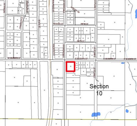
This land is clearly a rectangle, and it happens to be located in downtown Manton, Michigan. I drew a rectangle outlining the location of the land. The highway running north and south just to the left is old US highway 131, the new divided US 131 bypasses Manton. Note, this is a quit claim deed, in which George is relinquishing his claim to this piece of property. The deed does not tell us what that claim was.

l3p326 burdick

Seaman & Maqueston platted an addition to Manton, sometime after this deed was recorded. The description of the land there is now associated with Lot 1 of that addition, and is: “W 187 FT OF N 220 FT OF LOT 1, BLK. I SEAMAN & MAQUESTON ADDITION CITY OF MANTON”. According to History of Wexford County Michigan, compiled by John Wheeler and published in 1908, Seaman & Maqueston platted the addition to Manton in 1883 in In a closer view you can see the area where the property is located, as it looks today:
liber 3 p 326 close

In atlases of Wexford County published in 1889 and posted on line at the University of Michigan site, Michigan County Histories, the land is still empty, with the area where the lot is situated clearly marked as Lot 1, Block I of Seaman & Maqueston’s addition.

In the relatively current data posted on the Wexford County, Michigan Standard Map site, the property has apparently been consolidated again and looks like this:

liber 3 p326 current

I am not sure if George W. Burdick owned this land, or simply conveyed a certain interest it it to one of the men who eventually platted the addition.

Next: George W. Burdick makes another transaction concerning the same description.

The map views on this page were created from information at the Wexford County, Michigan Standard Maps site.

Granny’s Land Record Transcriptions

This entry is part 6 of 8 in the series Land Records

I received a Facebook comment with regard to my land record spreadsheet. I asked permission and added the comment at the end of the post here on my blog. A Facebook comment is soon lost in the feed of status updates, link posts and other miscellaneous garbage stuff information, and I prefer that comments and suggestions are kept with the original content if possible.

To paraphrase the comment, it suggested that I add the township and range to my land record spreadsheet index, and that I share the information on the appropriate county’s US GenWeb site. My reply was: Well, watch for the next part of the story. Since I have so many, I don’t have time right now to add the land descriptions to the spreadsheet. I’ll tuck that in the back of my mind for later, though. It is a good suggestion.

I have taken several days to mull this over, trying to figure out how to best share the information. I had given a pretty lengthy disclaimer with my post, something like this is not complete, might not have all index entries for a surname, might have errors, I’m human, and so on. I also said I might or might not have more information with regard to each index entry, but I would share what I had.

The Wexford County Courthouse is 200 miles from my home, and for quite an extended period of time, whenever my husband traveled that 200 miles for work, I hitched a ride and spent the workday at that courthouse.

My intent when I copied the land record index was to look up every land transaction for every member of our ancestral families that occurred in Wexford County. I did not include the township and range numbers on my index, although they are listed in the index books at the courthouse. I planned to record the legal description of the land from the deed record books. In fact, the working area was so cramped, and the office so busy, that my index listings were done on 8 x 5 “legal” pads. Those who know me often see me pull my tiny pads out of my purse, jacket pocket, or backpack. Every source for copies I have was first noted on one of those little pads, and I still have piles of them to reconcile with photographs and scanned documents which reside on my computer.

Between courthouse trips, I typed up an index which was in the form of liber|page|surname of interest, which I sorted by liber and page. On subsequent trips, armed with my form, and my “index”, I scribbled out transactions as quickly as I could. The results look something like this:binder

Somewhere along the line, my husband’s trips became less frequent, and finally ended when gas prices exceeded $4.00. The company found that phone calls were more economical.

A week or so ago, I found myself in need of material to post on this blog. I considered writing about ancestors, one at a time. I considered posting old family portraits, one by one. I looked around the house for something useful, and I found the land record book on the floor under the bed hidden in a corner on a shelf behind some other valuable items. As you can see, everything is more or less in a book, and nothing is attached to anything that resembles a gedcom or family tree, or anything, really. Having all these records accumulated, yet not analyzed and entered into my database with the proper family defeats the purpose of having them at all. Or at least I think it does. How can I learn anything if I don’t exercise my brain and fingers?

At the same time, I remembered that few of the family history researchers I have met have used land records. Although land records may be a familiar tool for professionals, many others are intimidated by the process, don’t know what they might learn from it, or haven’t even considered using land records. They may be mired in the quicksand of “hatch, match, and dispatch”. It seemed perfect to me, a chance to show a little about land records, how they can be used, what can be learned, and do it all while accomplishing something valuable and relevant to my research efforts. A great winter project.

From my perspective, the very nicely worded, kind comment came out of left field. The idea of loading all the data to US GenWeb had not occurred to me, nor is the data in a format that would be all that helpful. Changing my index by adding the township and range numbers seemed like busy work, and I wanted to do another kind of busy work.

I did not write 5000+ words to argue the pros and cons of someone’s helpful comment, it was to address how I have decided to handle the issue the comment raised. I revised my spreadsheet to include a column for township and range for each index entry and reposted it, you probably already noticed that if you followed the link. I will add the township and range to each entry as I work my way through the notebook. Although my goal will be to show the usefulness of land records, and give tips on how to get the most out of them, I will continue share the data with anyone who requests it. When I have worked my way through the entire pile, I will have the information in a format more useful to US GenWeb, and I will contribute it.

Deeds in the Family, the plot thickens!

Locating Property and Landmarks in Michigan.

This entry is part 5 of 8 in the series Land Records

As I have studied the land records of my families in Michigan, I have used a variety of maps and resources to be sure I know the location of each piece of property. I have likewise used multiple resources to visit homes, cemeteries, libraries and other research locations. Many of these are familiar, but perhaps some will be new and helpful.

Here are some resources you may find helpful. First, for Michigan:

  1. A set of county maps from Michigan State University. These maps are PDF format and downloadable. There are zip code maps, transportation maps, hydrology maps, current census district maps, land use maps level 1 and level 2, and my favorite, the (MCD) Minor Civil Division maps which show cities, villages, towns and townships including the township and range number. I use these all the time and find them very valuable.
  2. Michigan subdivision plats. When a deed says, “assessor plat No. 1”, or “Mr. So-and-so’s” 2nd addition to the city of Podunk”, this is your site. Search by county, or enter the name of the plat or subdivision. A great resource! (My disclaimer, added October 30, 2009: I don’t know what happened to Michigan’s website with this data. I know the link on the State page is not working right now. I hope it will work again soon.)
  3. Michigan County Histories and Atlases. Click the subject link, and enter your county. There are historic atlas as of many Michigan counties on this site. Be sure to browse and search the histories of the counties your ancestors lived in while you are here.
  4. Be sure to find the website of the Michigan county your family resided in. Some counties have free downloadable or usable “Base Maps” or “Standard Maps”, with helpful information. There are also maps which require a subscription, or purchase, but take your time and you may find some gems. As an example, check what I found for Oakland County, and Wexford County. Some cities also offer this service, just look around websites of governmental units in your target area.

Now, for good measure, some map and map related sites that can be used for Michigan, and other areas, too.

  1. The United States Geographic Names Information System (GNIS). All things geographic. Find cemeteries, mountains, just about anything but your ancestor on this site.
  2. USGenWeb Project, United States Digital Map Library. You never know what you will find here.
  3. National Atlas Dot Gov. : This huge site is a resource for all things map in the United States. There is a primer on the Public Land Survey System (PLSS), and a large group of maps for many purposes.
  4. The Newberry Library interactive maps. Historical boundaries, cool overlays, useful.
  5. David Rumsey map collection. A variety of maps, and worth a look.
  6. Earth Point tools for Google Earth. A high tech solution for finding township and range locations in Google Earth. I listed the last because it is a subscription service. However, you can test drive it, and one subscription option is very reasonable.

Next time, I outline a plan to make my deed transcriptions available to interested researchers. I will also continue to describe what I have learned from deed records.

Liber 2 Page 403 What Does the Deed Tell Me?

This entry is part 2 of 8 in the series Land Records

Here are the basic facts from the transcription of the deed recorded in Liber 2 page 403 of Wexford County Deeds.

  1. The Grantor, Erasmus D. Abbott, of Sherman, Wexford, County, Michigan
  2. The Grantee: George W. Burdick of Cedar Creek, Wexford County, Michigan
  3. The witnesses: Oscar Barnes, a justice of the peace and William Briggs
  4. A warranty deed, received by clerk H.B. Sturtevant for recording on 20 May 1874
  5. The land transferred: the E1/2 of the NE1/4 of Section 4, township 23N range 10W, about 80 acres more or less.
  6. The deed was signed, ED Abbott, and the transaction cost George W. Burdick $200.

Since this is not a Weekly Reader test, I will omit the information that is not relevant to my genealogical research. The clerk’s name is not significant, and in this case neither is the name of one of the witnesses. I did notice that the other witness had the last name Barnes, and we do have some Barnes relatives.

I collected the location of this deed because if mentioned the surname BURDICK. At the time I collected the information, I was not researching any Abbott lines. George Washington Burdick was one of Papa’s ancestors, here is what I know about him, much of it from an old, unsourced family history. The highlighted information is the new land transaction:

27 April 1827 Birth: Berlin, Rensselaer Co., NY
1850 Census: Andover, Allegany Co., NY
1855 Marriage: Mary Jane Abbott
1850 Census: Andover, Allegany Co., NY
29 March 1856 Daughter: Susie Melissa born, Andover, Allegany Co., NY
1860 Census: Andover Allegany County, New York
24 Oct 1860 Son: Fink Clement born Andover, Allegany Co., NY
24 Oct 1860 – 23 Jn 1868 Migration: New York to Pennsylvania
23 June 1868 Daughter: Mable Genevieve born, Eleven Mile, Potter Co., PA
23 June -May 1870 Migration: Pennsylvania to Michigan
27 Aug 1870 Census: Colfax, Wexford County, Michigan
11 Jan 1871 Daughter: Gertie W. born Colfax, Wexford Co., MI
12 Mar 1874 News item: The Grand Traverse Herald; Boardman, Grand Traverse County, Michigan
Listed as arrivals at the Boardman River House for the week ending March 9th: (lengthy list) Geo. W Burdick, Manton.
20 May 1874
Land Purchase: E 1/2 of the NE1 /4 Sec. 4 T23N R10W Wexford Co., MI
1880 Census: Colfax Township, Wexford County, Michigan
8 Jan 1885 News item: the Grand Traverse Herald “Geo. W. Burdick will log quite extensively in Colfax this winter.”
1910 Census: Colfax Township, Wexford County, Michigan
24 Oct 1914 Death: Irons, Lake County, Michigan
26 Oct 1914 Burial: Colfax Township, Wexford County, Michigan

What have I learned from this exercise? What can this added information do to help me?

  1. George W. Burdick owned land in Colfax, Wexford, MI in 1874.
  2. The old family history gave the children’s birthplaces is looking better and better.
  3. G.W. Burdick purchased land from a man named Abbott, is he related? My marriage references are a little weak, consisting of an old family history and some obituaries, both constructed long after the date of the marriage. Perhaps there is an association between the Erasmus Abbott, from whom G.W. Burdick purchased this land and Mary Jane Abbott, that might better substantiate the marriage.
  4. Is Oscar Barnes related to the Barnes family which another of our families married into?
  5. Was GW renting land or a home before this purchase? He was on the 1870 census in this township.

In a vacuum, this purchase of 80 acres is not too significant. However, as a piece in the puzzle of the G.W. Burdick family, it can help me to know the family better. Stay tuned!

Liber 2 Page 403 Land Records, what next?

This entry is part 3 of 8 in the series Land Records

I am writing a little about my experience working with deed records, using Wexford County, Michigan as an example. After I had collected a list of the names and location of the records, I started through the deed record books using my form.

It might be helpful to explain that although recording this information directly onto my laptop would have been desirable, there simply was not room in the vault at the Wexford County Court House. Although some courthouses have more room, at the time that I researched the Wexford County deeds, the vault was four walls of books, filed from floor to ceiling and one table in the middle, slanted to accommodate the books. There was room for about 4-6 people, standing up at the table. Moving the rolling ladder to climb to reach the volumes near the ceiling necessitated having everyone on that side of the table move. Even if there had been room for my laptop, the angle of the table was such that it would have slid off, so using it was not even an option.

So, the laptop remained on the floor in it’s bag, and I used the form. Here is an example of the information I collected.
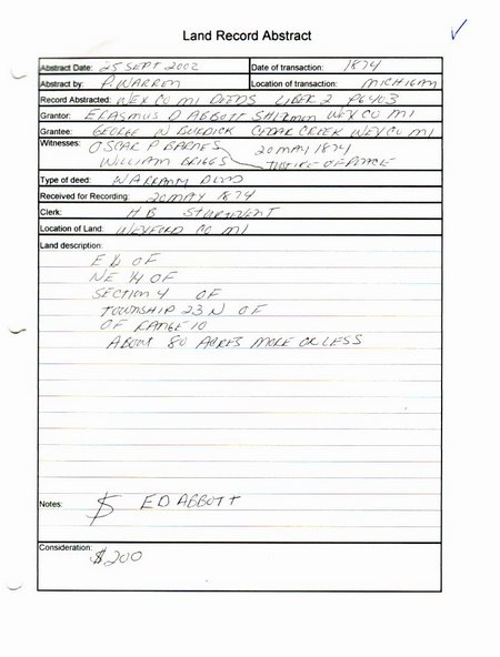
l2p403 wex mi deeds

  • I collected this information on 25 Sept, 2002
  • The record was Liber 2, page 403, Wexford County, Michigan Deeds
  • The Grantor, Erasmus D. Abbot, of Sherman, Wexford, County, Michigan
  • The Grantee: George W. Burdick of Cedar Creek, Wexford County, Michigan
  • The witnesses: Oscar Barnes, a justice of the peace and William Briggs
  • A warranty deed, received by clerk H.B. Sturtevant for recording on 20 May 1874
  • The land transferred: the E1/2 of the NE1/4 of Section 4, township 23N range 10W, about 80 acres more or less.

Yes, I didn’t put the W on range 10, I plead guilty. But, I know it is R10W, many of the transactions for Papa’s family are in that township, which is Colfax Township, Wexford County, Michigan. I would have had to do a little more investigation if I had not completely recorded information from a deed in a jurisdiction I knew less about.

  • The deed was signed, ED Abbott, and the transaction cost George W. Burdick $200.

For those who have never worked with land descriptions, here is an overview the land descriptions, how to understand them, and what they tell us. This will be the short course, for those who already know or for those who learn like I do, by the seat of their pants.

If you know nothing about land descriptions and the English survey system, use one of these references or many others that are available:

The portion of this description that tells the township and section location of the land would be normally be written T23N R10W. This little code describes the land in relationship to the survey baseline (which runs east to west) and the meridian (which runs north to south) of the survey. In Michigan, the baseline of the survey is Eight Mile Road (cue the movie jokes). At the baseline, the townships change from north to south. The meridian is actually called Meridian Road. At the meridian, the townships change from east to west.

A township is a square tract of land with four sides of 6 miles each, which contains 36 sections of land. The sections are numbered from the top right (east) corner, from right to left across the township, numbers 1-6. Then, dropping down below section 6, the sections are numbered 7-12 from left to right across the township.

(This is more advanced, skip if you want to.) Because the earth is not flat, shortages develop as the survey extends north from the baseline and east or west the meridian. The surveyors adjusted for shortages of land which developed as the survey went north by assigning some land to Government lots, or calling odd acreages a fractional 40, or a fractional 80. In Wexford county, the north and west edges of each township have odd acreages.

Michigan has a number of useful maps online on the DNR site. You can see a map of Michigan Townships here. The map opens in PDF format, change the view to 100% or more. You can follow the meridian up from the state line by looking for the numbers in red circles, 30 and 46 at the bottom of the map, along the state line. The Meridian runs between T8S R1W and T8S R1E. You can trace it all the way up through the state on the line between R1W and R1E. It runs north, on the west (left) sides of the political townships of Medina, Hudson, Rollin, Woodstock, Columbia, Napoleon, Leoni, and Henrietta to the baseline. The meridian and the base line intersect between Leslie and Bunker Hill Townships in Ingham County. You can follow the baseline from it’s intersection with the Meridian east (right), to the point were T1N R10E, political township Southfield, and it’s neighbors, Royal Oak, Warren, and Roseville border the north side of the Meridian at Eight Mile Road (cue the movie music).

In Michigan, the named political townships do not always follow the border of the survey townships. It happens that they do in Wexford County.

The 36 townships end up looking like this:
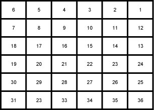
sections

My description is in section four, which is the fourth section from the northeast corner of the section. Each section of land is one mile square. A section is 640 acres, a half-section is 320 acres and a quarter-section is 160 acres.

Now, the fun begins.

Any portion of a section, or a quarter of a section can be divided into quarters, which are described and positioned like this:

quarters

Any portion of a section, or a quarter section can be divided in half two ways which are described and positioned like this:
e-w halves

Or this:
n-s halves

The land can be divided many times this way. Now, back to my the reason for this discussion, my description. I already know the township and range, so I can disregard that for a moment. In my little section, number 4, the land was the east 1/2 of the northeast 1/4. I always think “upside down” on this. What is the northeast 1/4?   It is the part that is the upper right quadrant of any piece of land. What is the east 1/2? It is the half on the right side.

So, to find the E 1/2 of the NE 1/4 I would look here:
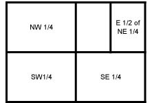
ehalf ne quarter
Looking at Wexford County, this describes land which is in this position:
easthalf-northeastquarter

Now, knowing exactly where the land is in a little drawing is nice, what can I do with that information? Check back next time!

Wexford County Deeds, Part 2

This entry is part 4 of 8 in the series Land Records

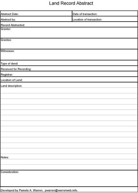
Now I had a neat spreadsheet of land records I extracted from the Wexford County, Michigan index books. What should I do next?  There were so many deeds, and I was not equally interested in them.  Or, at least at the moment I created my list from the index,  some were more important to me than others.  I copied every one I could find for my names, just to be sure I would not have to go back over the books again. With such a long list, it was not possible for me to purchase copies of every deed. So I did what any good project manager would do, and designed a form to collect the information from the records, it looks like this:

land record abstract form

You can see the information I was interested in, it pretty much follows the format of a warranty deed. Just to clarify, I recorded:

  1. The date I was extracting the information
  2. The date of the land transaction, this is usually at the bottom with the signatures and notarizing
  3. My initials/name as the person who extracted the information
  4. The location of the transaction, I actually recorded the county and state the deed was recorded in.
  5. The Grantor, the person or entity selling the land.
  6. The Grantee, the person or entity purchasing the land.
  7. The names of the witnesses
  8. The type of deed, warranty, quick claim, whatever it was
  9. The date the registrar received the deed to record
  10. The name of the Registrar
  11. The location of the land, usually a county and township
  12. A description of the land, varies with location but is written out in the deed.
  13. Any notes I felt I needed to make
  14. The “consideration”: what was paid for the land.

If you would like to use my form, I have posted an Excel version, and a PDF version. Please do not publish the form, just link back here and let any interested party download their own copy.

Tomorrow: How a filled out form looks. What did I learn?

With regard to my spreadsheet, Just a disclaimer, again. They are selected records only, not complete indices. There may be transcription errors. I searched the indices for family names, but many not have recorded every deed for every family. I recorded both the grantor and grantee for each deed, and created a spreadsheet of the results. I may or may not have further information on these transactions, but it will not cost you anything to ask, and I will share anything I have.