I am writing a little about my experience working with deed records, using Wexford County, Michigan as an example. After I had collected a list of the names and location of the records, I started through the deed record books using my form.
It might be helpful to explain that although recording this information directly onto my laptop would have been desirable, there simply was not room in the vault at the Wexford County Court House. Although some courthouses have more room, at the time that I researched the Wexford County deeds, the vault was four walls of books, filed from floor to ceiling and one table in the middle, slanted to accommodate the books. There was room for about 4-6 people, standing up at the table. Moving the rolling ladder to climb to reach the volumes near the ceiling necessitated having everyone on that side of the table move. Even if there had been room for my laptop, the angle of the table was such that it would have slid off, so using it was not even an option.
So, the laptop remained on the floor in it’s bag, and I used the form. Here is an example of the information I collected.

- I collected this information on 25 Sept, 2002
- The record was Liber 2, page 403, Wexford County, Michigan Deeds
- The Grantor, Erasmus D. Abbot, of Sherman, Wexford, County, Michigan
- The Grantee: George W. Burdick of Cedar Creek, Wexford County, Michigan
- The witnesses: Oscar Barnes, a justice of the peace and William Briggs
- A warranty deed, received by clerk H.B. Sturtevant for recording on 20 May 1874
- The land transferred: the E1/2 of the NE1/4 of Section 4, township 23N range 10W, about 80 acres more or less.
Yes, I didn’t put the W on range 10, I plead guilty. But, I know it is R10W, many of the transactions for Papa’s family are in that township, which is Colfax Township, Wexford County, Michigan. I would have had to do a little more investigation if I had not completely recorded information from a deed in a jurisdiction I knew less about.
- The deed was signed, ED Abbott, and the transaction cost George W. Burdick $200.
For those who have never worked with land descriptions, here is an overview the land descriptions, how to understand them, and what they tell us. This will be the short course, for those who already know or for those who learn like I do, by the seat of their pants.
If you know nothing about land descriptions and the English survey system, use one of these references or many others that are available:
- The Public Land Survey System at National Atlas dot Gov
- Public Land Survey Information at the Geospatial Training and Analysis Cooperative
- Good old Wikipedia
- The Bureau of Land Management
The portion of this description that tells the township and section location of the land would be normally be written T23N R10W. This little code describes the land in relationship to the survey baseline (which runs east to west) and the meridian (which runs north to south) of the survey. In Michigan, the baseline of the survey is Eight Mile Road (cue the movie jokes). At the baseline, the townships change from north to south. The meridian is actually called Meridian Road. At the meridian, the townships change from east to west.
A township is a square tract of land with four sides of 6 miles each, which contains 36 sections of land. The sections are numbered from the top right (east) corner, from right to left across the township, numbers 1-6. Then, dropping down below section 6, the sections are numbered 7-12 from left to right across the township.
(This is more advanced, skip if you want to.) Because the earth is not flat, shortages develop as the survey extends north from the baseline and east or west the meridian. The surveyors adjusted for shortages of land which developed as the survey went north by assigning some land to Government lots, or calling odd acreages a fractional 40, or a fractional 80. In Wexford county, the north and west edges of each township have odd acreages.
Michigan has a number of useful maps online on the DNR site. You can see a map of Michigan Townships here. The map opens in PDF format, change the view to 100% or more. You can follow the meridian up from the state line by looking for the numbers in red circles, 30 and 46 at the bottom of the map, along the state line. The Meridian runs between T8S R1W and T8S R1E. You can trace it all the way up through the state on the line between R1W and R1E. It runs north, on the west (left) sides of the political townships of Medina, Hudson, Rollin, Woodstock, Columbia, Napoleon, Leoni, and Henrietta to the baseline. The meridian and the base line intersect between Leslie and Bunker Hill Townships in Ingham County. You can follow the baseline from it’s intersection with the Meridian east (right), to the point were T1N R10E, political township Southfield, and it’s neighbors, Royal Oak, Warren, and Roseville border the north side of the Meridian at Eight Mile Road (cue the movie music).
In Michigan, the named political townships do not always follow the border of the survey townships. It happens that they do in Wexford County.
The 36 townships end up looking like this:
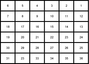
My description is in section four, which is the fourth section from the northeast corner of the section. Each section of land is one mile square. A section is 640 acres, a half-section is 320 acres and a quarter-section is 160 acres.
Now, the fun begins.
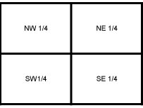
Any portion of a section, or a quarter of a section can be divided into quarters, which are described and positioned like this:
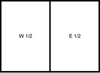
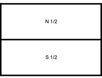
Any portion of a section, or a quarter section can be divided in half two ways which are described and positioned like this:
Or this:
The land can be divided many times this way. Now, back to my the reason for this discussion, my description. I already know the township and range, so I can disregard that for a moment. In my little section, number 4, the land was the east 1/2 of the northeast 1/4. I always think “upside down” on this. What is the northeast 1/4? It is the part that is the upper right quadrant of any piece of land. What is the east 1/2? It is the half on the right side.
So, to find the E 1/2 of the NE 1/4 I would look here:
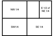
Looking at Wexford County, this describes land which is in this position:

Now, knowing exactly where the land is in a little drawing is nice, what can I do with that information? Check back next time!
Pam,
I really like the template you’re using for abstracting/extracting the deed information. Mind if I steal, eh, borrow it?
Julie
P.S. I’m hoping to visit Oakland Co. this year. Hope we can meet up!
.-= Julie Tarr´s last blog ..Legacy Family Tree v7.4 Integration With FamilySearch =-.
Yes, please do Julie, I wrote about it and posted links to a version that you can download in this post.
Hope to see you in Michigan, and hope I’ll be here when you visit so I can feed.
This article was very informative. It was real easy to follow and understand. (I am still pretty new to genealogy!)
.-= Alice Dilts´s last blog ..Treasure Chest Thursday – 01/14/10 =-.
Thanks, Alice. Simple explanations are often the best!